Frequently Asked Questions
What does a Land Surveyor do?
A land surveyor's main goal is to identify boundary lines based on the legal description of properties and physically mark them on the ground. Most often the public assumes where a fence is or where their neighbor has been mowing the grass is the boundary line but this is not always the case. Another common task of a surveyor is to locate the physical features of a property and from that information is able to create a Certificate of Survey (a form of a map) showing the details of property.
Why do I need a survey?
Surveys are requested for a variety of different reasons; preliminary design before construction, purchase or sale of real estate, land disputes, fence projects, or often a city or county will request a survey before improvements or alterations can be made to the property. It is best to get a survey done sooner than later to avoid future complications.
What should I do before contacting a surveyor?
If you are getting a survey done for any building purposes or if you wish to split/adjust your boundary, contact your local city or county first. They will have certain requirements and ordinances that may determine the path of your project.
Will my survey include a Certificate of Survey?
Only by request, will a Certificate of Survey be supplied. However, the majority of surveys performed are for reasons that already require a Certificate of Survey. If you need a survey done because a municipality requested it, you may need a Certificate of Survey showing significant details of your property.
How does the surveyor know where my corners are?
Boundary and lot corners are determined by calculating and referencing from neighboring monuments or from the section corners that the property relates to.
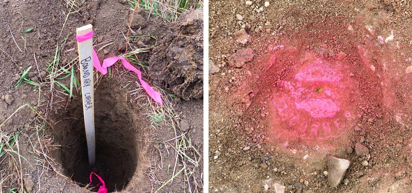
How will I know where my corners are?
Most often the corners will be marked by a wooden lath/stake with pink flagging tied to it. Corners that land on hard surfaces such as concrete will be marked with spray paint. Don’t be fooled by thinking that the wooden lath/stake is the corner, the actual corners are typically iron pipes that are buried in the ground. The lath/stake will be written on describing its relation to the actual corner.
How does my new legal description get recorded?
Whitetail Land Surveying does not record new legal descriptions. We do supply the Certificate of Survey and new legal description. It is best to consult with an attorney or title company to finish the process of getting the description recorded. In some cases, the County Recorder may be able to help with this process.
What will my survey cost?
In some cases, a set price can be agreed upon for more routine surveys that have little anticipation for encountering difficulties but every survey is different. Many people assume that a smaller piece of property means it will cost less, this is not always the case.
Many factors make up the estimate of a survey:
- Has it been surveyed recently or ever
- What is the terrain
- Is it heavily wooded
- Are there records of the property
- Is the boundary description clear and without ambiguities
- Is it platted or unplatted
- What details of the property all need to be shown as part of the survey
The overall estimate will depend on the anticipated difficulty and time required to complete the project.
What is the process for getting a survey and how long does it take?
Sometimes a survey many require only a single visit for projects like locating corners of gathering a few details of the property but some surveys may require multiple visits at different phases of the project. Larger projects will begin with an initial survey of the existing condition information – which is prepared as a Certificate of Survey. From this certificate architects and engineers are able to prepare their plans during the design phase. Once the design is approved, the surveyor will visit the site again to stake/layout the outline of the proposed improvements. During the construction it may be required for the surveyor to again visit the site for an as-built to certify that the improvements are being built according to plan. After construction is complete, the surveyor will make a final site visit to gather all required finished details of the project in order to prepare a final as-built survey.
Does anyone need to be home during the survey?
Typically, there is no need for anyone to be present during the survey. All of our work is done from the outside and we just request that any gates be unlocked so the surveyor can access the yard freely. Please be sure to have your pets inside.
Do you do surveys during the winter?
Yes, many of the services provided can still be done in the winter, they may just become more time consuming. Projects which involve topography and locating hardcover surfaces can be more difficult to complete with the snow and ice cover.